|
|

Despite its urban sprawl, Bristol can still be seen as a
collection of distinctive geographic areas, each with its own
history, which together give the city its identity. Here is information
on just a few of them.
The Centre
Bristol's centre was originally near Bristol Bridge, at the crossroads
formed by the High Street, Wine Street, Corn Street and Broad
Street. When people refer to The Centre today they usually
mean the area that was once the site of the Tramways Centre
(the hub for the city's tram routes) between Broad Quay and
St Augustine's Parade. This area was redeveloped in the 1990s
in an effort to overcome congestion problems and to provide
a more clearly defined and exciting public space. Critical
reaction to the scheme has been less than enthusiastic, but
there was little affection for how it looked before either.
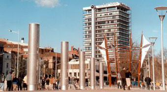
The
Centre, c 2005.
Many years ago, the place where
the fountains now play used to be a busy dockside. The waters
of the northern section of St Augustine's Reach – a man-made
channel dug in the thirteenth century during the diversion of
the River Frome – were covered over in the 1890s because of increased
demands from road traffic. Its water still flows under the tarmac
and paving stones. This is what the area looked like in the late
eighteenth century when Bristol was at its height as a trading
port.
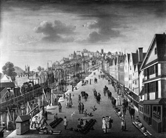
Broad Quay, Bristol, attributed to Philip
Van Dyke, c 1760 (Bristol's Musems, Galleries and Archives).
The Centre is the site of the Bristol Hippodrome, pictured below,
which was built in 1912. West End shows that have been premiered
here include Guys and Dolls (1953) with Sam Levene and Stubby
Kaye, The Music Man (1961) with Van Johnson, and the Disney-Sam
Mackintosh production of Mary Poppins (2004).
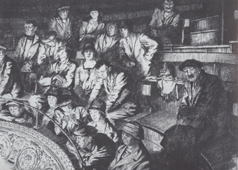
In the Gallery by
Alexander J Heaney, c 1928 (Bristol's Museums, Galleries and
Archives).
Temple
The lead statue of King Neptune in The Centre's pedestrianised
area has been moved several times since it was cast in 1722.
Here it is seen in its first home near Temple Church when it
was still painted in colour rather than its current grey.
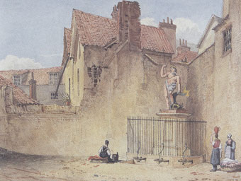
The
Neptune, Church Lane, near Temple Church by George W Delamotte,
1825 (Bristol's Museums, Galleries and Archives).
The
area of Temple, south of the Bristol Bridge, was given to the
Knights Templar in 1145 by Robert, Earl of Gloucester and it
is often referred to as the city's first suburb. The knights
were soldier-monks who guarded pilgrims travelling to the Holy
Land. Bristol gained control of Temple following the Reformation
when the monasteries were abolished. It was once the centre of
Bristol's weaving trade and the guild had its chapel in Temple
Church. This area was among those targeted by German bombers
in the Second World War and the church was severely damaged during
the Blitz. (Read about the Blitz in the Bristol at War story
on The
Siege website.) The bombed-out shell is now a listed monument, owned
by English Heritage. The tower is not leaning because of the
bombing: it had already started to tilt when it was being built
in the fourteenth century, but has managed to survive.
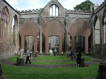
Temple
Church pictured on the Church
Crawler website.
Queen Square
Elegant Queen Square, one of the largest residential squares
in Europe, was named in honour of Queen Anne when she visited
the city in 1702. It was built on The Marsh, which had previously
been used as an archery training ground, bowling green, boat
yard and for general recreation. The square was once home to
some of Bristol's wealthiest merchants as well as being the
site of the first American Consulate in Britain, established
in September 1792.
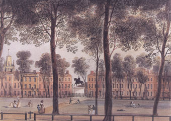
Queen Square Bristol from the North West
Corner by Thomas L Rowbotham, 1827 (Bristol's Museums, Galleries
and Archives).
The square was also the focus
of the Bristol Riots of 1831, which stemmed from discontent at
the corruption of city officials and the defeat of the Reform
Bill. Many buildings were burnt to the ground during the rioting
and several people were killed. Of those arrested by the authorities,
four were hanged and nearly 100 transported to the colonies.
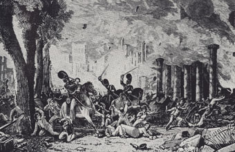
Bristol
Riot, 1831 (Bristol's Museums, Galleries and Archive).
Although the destroyed buildings were gradually replaced, the
square failed to recover its former prestige, most of the private
homes becoming increasingly downmarket lodging houses, and during
the late 1930s it suffered the indignity of having a dual carriageway
built across it. In the 1990s, Bristol City Council initiated
plans to renovate the square, removing the dual carriageway,
restoring gravel paths, digging up tarmac to reveal the original
setts (cobbles) beneath and planting mature saplings to fill
gaps between the trees. The official re-opening of the square
took place in September 2000 and it is once again one of the
most attractive public spaces in the city. The surrounding buildings
are now nearly all used as office space.
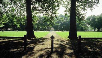
Queen Square, c 2005
(Destination Bristol).
Clifton
Many of the merchants who first lived in Queen Square had already
started to move out to the new terraces of Clifton before the
Riots took place. The manor of Clifton – then known as Clistone
– is mentioned in the Domesday book (1085). It remained a small
hamlet of scattered farms and houses until the 1700s when it
experienced a building boom, having been purchased by the Society
of Merchant Venturers in 1676. Wealthy city-dwellers were attracted
by its clean air and the views across the downs and gorge,
and the population rose from around 450 in the early eighteenth
century to nearly 4,500 in the 1801 census. Clifton was incorporated
into the city in 1835.
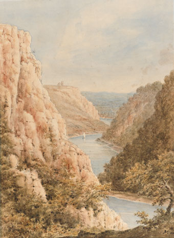
An early nineteenth-century watercolour
of Clifton Gorge by Marianne Smith (private collection). This
predates the building of Brunel's Suspension Bridge but the Clifton
Observatory can be seen in the distance.
Visitors
were also attracted to the hot springs here in Clifton and at
nearby Hotwells, coming in the summer season before moving on
to the even more fashionable Bath spas in the winter. The French
Wars of the 1790s brought bankruptcy to many of the merchants
and property speculators who had invested in the development
of Clifton, bringing several of the building projects to a halt.
Despite this set back, significant terraces and, later, villas
continued to be constructed into the mid-nineteenth century and,
architecturally, Clifton remains one of the most impressive areas
of the city.
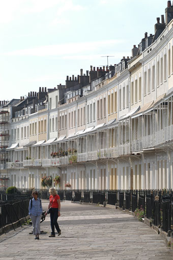
Royal York Crescent, built c 1791-1820,
photographed c 2005 (Destination Bristol).
St Paul's
St Paul's was developed as a city suburb on Bristol's eastern
fringe in the late eighteenth century to accommodate the rapid
growth of the local population. It was originally home to the
merchant class and Portland Square, now mainly used for offices,
was once one of the city's most desirable addresses. St Paul's
Church, which is to the east of the square, was known as the
Wedding Cake Church because of its unusual tiered tower. It
was completed in 1794, but was forced to close in 1988 because
of its dwindling congregation. It is now home to Circomedia,
the circus skills groups, and won the top accolade for 'Community
Benefit' in the 2007 Royal Institute for Chartered Surveyors
Awards in the South West.
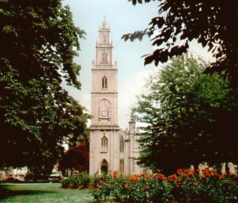
St Paul's Church pictured on the About
Bristol website.
In the nineteenth century, St Paul's was an industrialised
area, having a particular speciality in boot- and furniture-making
businesses. By the Second World War it had become severely neglected
and run-down, with only those too poor to move away to the safety
and comfort of the suburbs remaining in residence there. Some
of the more decrepit terraces were replaced by new low-rise flats
in the postwar period but this did little to stop the continuing
blight. When migrants from the Caribbean began arriving in Bristol
in the 1950s, it was one of the few areas in the city they could
afford to live. Landlords let the buildings decay further, having
no incentive to improve them as they knew their tenants were unlikely
to find any alternative accommodation in the city. Despite the
poverty and social inequality, with its associated problems of
drugs and crime, there is a positive community spirit in St Paul's,
marked by initiatives such as the Afrikan-Caribbean Carnival, which
was founded in 1967, and by the St Paul's Unlimited scheme, which
aims to make constructive changes to the environment and lives
of the residents.
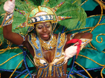
Image of the carnival pictured
on the St
Paul's Carnival website.
Bedminster
Bedminster, a royal manor listed in the Domesday Book and with
Roman origins, did not officially become part of Bristol until
the boundary changes of the 1890s, though it had long been
considered as a city suburb. It lies south of the New Cut,
a bypass to the river Avon running from Temple Meads to Hotwells,
which was created in the early nineteenth century during construction
of the non-tidal Floating Harbour.
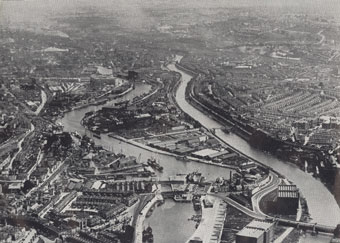
Aerial view of the Avon and
the New Cut in the 1930s, with Bedminster to the right of the
picture.
The area prospered during the Industrial Revolution
when it was home to collieries, brickyards, iron founderies,
tanneries, glassworks, potteries, breweries, and glue-, paint-
and paper-making factories. Between 1801 and 1851, the population
rose from just over 3,000 to nearly 19,500 as people were attracted
by the employment opportunities, and new or extended housing developments overflowed
into Windmill Hill, Totterdown, Southville and Bedminster Down.
By the end 1880s, when the Wills tobacco factory moved to here
from Redcliffe, the population was nearly 80,000.

Headquarters
of W D and H O wills in East Street, Bedminter c 1900.
Bedminster suffered badly during the bombing of
the Second World War and also in the postwar redevelopment of
the city, but has undergone a renaissance in recent years, in
part thanks to the presence of the Tobacco Factory theatre and
bar, and to a range of independent shops and businesses along
North Street.
Sea Mills
During the slum clearances in the centre of Bristol after the
First World War, people were encouraged to move from the city
centre to new housing on the suburban fringes such as the Seas
Mills Municipal Estate. Houses on the estate had their own
gardens, indoor sanitation, hot water and lighter, better equipped
kitchens. Fields and parks nearby provided play areas for children
away from the streets, and new schools were also built. The
disadvantage of these new estates was that they had few shops
and were a long distance from work for those still employed
in the city centre.
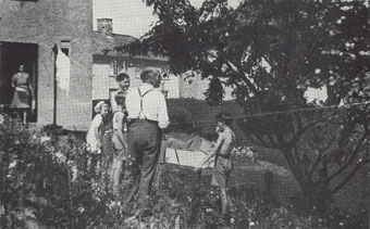
A family enjoying their new Sea Mills'
garden in the 1930s.
In the housing shortage that followed
the Second World War, temporary pre-fabricated houses were erected
at Sea Mills, some of which are still occupied.
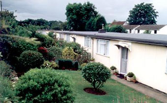
Pre-fabs in Sea
Mills, pictured on the About
Bristol website.
There had been a settlement at Sea Mills
in Roman times and an attempt to build a dock here in the eighteenth
century, but it was these postwar developments that made the
area what it is today. Other areas that were originally established
as garden-suburbs for the city included Knowle West and Fishponds.
|
|

Tell us about the area of
Bristol in which you live, study or work. Submit your
contribution via the My
Bristol page. |
| |